


Maps
Hello! My name is Manuel and I am going to tell you all about geological maps. Maps are basically drawings showing where all sorts of things can be found.
Normal maps show things like roads, buildings, parks and rivers  . You might have used one to find out where a friend lives or to show the way on a walk.
There are also special maps that have extra information about different things like how many people live in each town and what sort of food is grown where.
Key:

Hospital

Swimming

Restaurant

Parking

Maps usually come with a key which explains what all the symbols on the map mean.
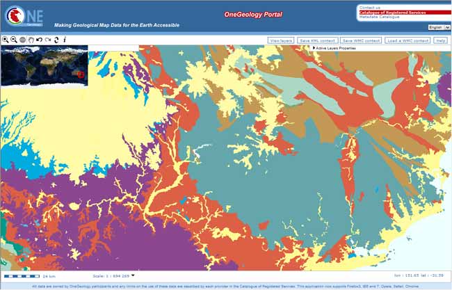
Geological maps like the OneGeology maps, show what the rocks are beneath our feet, like in this one.
![]()
Different types of rock  are shown by different colours — these aren’t always the same colour as the rock itself otherwise there would be lots of browns and greys!
OneGeology has put all of the geological maps from around the world into one place! This is exciting as these geological maps can tell you:
- About the rocks beneath the soil and what the environment used to be like a long time ago (like when dinosaurs lived on the Earth).
- Where to find fossils
 , minerals and oil, gas
  or water
  .
. - Geological maps also tell you where rocks have moved and been folded and squashed into mountains like metamorphic rocks . The Earth has developed and changed a lot over time.
Geological map of the world
The map below is a geological map of the world. Can you see the different continents (hover over to see them on the map)? The different colours show that the Earth is made up of many different kinds of rocks.
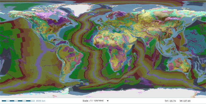
Can you see how some continents look like they could fit together (have a look at South America and Africa). Well, by using the information on geological maps, it has been shown that the continents were, once, all one big land mass.
Get involved
- Test what you've learnt about geology and maps in the quiz
Let’s see what else we can find out about geological maps. Try searching the internet for:
- geological map
- continents